

Beautiful RARE certificate from the Richmond Beach Hotel Company issued in 1881. This historic document has an gold gild ornate border around it with a vignette of the Richmond Beach Hotel. This item has the signatures of the Company's President and Secretary and is over 125 years old. 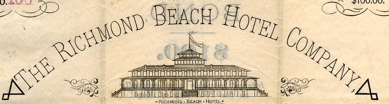
Certificate Vignette Huguenot Park was formerly Richmond Beach in Staten Island. Staten Island is one of the five boroughs of New York City, located on an island of the same name on the west side of the Narrows at the entrance of New York Harbor. It is coterminous with Richmond County, the southernmost county of the State of New York. Singer Christina Aguilera and several members of Wu-Tang Clan were born on Staten Island. The existence of the borough dates from the unification of New York City in 1898. Until 1975, however, the borough was officially known as the Borough of Richmond. Despite having an estimated population of 463,314 in 2004 (as well as being the fastest growing county in New York State), it has often been termed "the forgotten borough," as it is much less well-known than its four sisters, The Bronx, Queens, Manhattan, and Brooklyn. By far the least populated, most ethnically homogeneous, and most remote borough of New York City, Staten Island is sometimes the object of humor by residents of the other boroughs as being somewhat enigmatic and rustically suburban. Indeed, much of the central and southern sections of the island were once dominated by farms, primarily dairy and poultry farms, some of which were still in existence as recently as the early 1960s. Yet the borough's steady rise in population since the opening of the Verrazano-Narrows Bridge has added to a sharp increase in traffic that plagues the island and are a cause of frequent road repairs and accidents. The bedrock of the island is a diabase sill formed during the volcanic eruptions that created much of the bedrock of northern New Jersey, including the New Jersey Palisades, approximately 200 million years ago. As an island, Staten Island was formed in the wake of the last ice age. In the late Pleistocene between 20,000 and 14,000 years ago, the ice sheet that covered northeastern North America reached to as far south as present day New York City, to a depth of approximately the same height as the Empire State Building. At one point, during its maximum reach, the ice sheet precisely ended at the center of present day Staten Island, forming a terminal moraine on the existing diabase sill. The central moraine of the island is sometimes called the Serpentine ridge because it contains large amounts of that particular mineral. At the retreat of the ice sheet, Staten Island and Long Island were not yet separated by the Narrows, which had not yet formed. Geologists reckoning of the course of the Hudson River have placed it alternatively through the present course of the Raritan River, south of the island, as well through present-day Flushing Bay and Jamaica Bay. As in much of North America, human habitation appeared in the island fairly rapidly after the retreat of the ice sheet. Archaeologists have recovered tool evidence of Clovis culture activity dating from approximately 14,000 years ago. The island was probably abandoned later, possibly because of the extinction of large mammals on the island. Evidence of the first permanent Native American settlements and agriculture date from about 5,000 years ago (Jackson, 1995). In the Sixteenth Century, the island was part of a larger area known as Lenapehoking that was inhabited by the Lenape, an Algonquian people also called the "Delaware". The band that occupied the southern part of the island was called the Raritans. To the Lenape, the island was called "Aquehonga Manacknong" and "Eghquaons" (Jackson, 1995). The island was laced with foot trails, one which followed the south side of the ridge near the course of present day Richmond Road and Amboy Road. The Lenape did not live in fixed encampments, but moved seasonally, using slash and burn agriculture. The staples of their diet included shellfish, including the oysters that are native to both Upper New York Bay and Lower New York Bay. Staaten Eylandt The first recorded European contact with the island was in 1524 by Giovanni da Verrazano who sailed through the Narrows. In 1609, Henry Hudson established Dutch trade in the area and named the island Staaten Eylandt after the Staten-Generaal, the Dutch parliament. Although the first Dutch settlement of the New Netherlands colony was made on Manhattan in 1620, Staaten Eylandt remained uncolonized by the Dutch for many decades. From 1639 to 1655, the Dutch made three separate attempts to establish a permanent settlement on the island, but each time the settlement was destroyed in the conflicts between the Dutch and the local tribes. In 1661, the first permanent Dutch settlement was established at Oude Dorp (Dutch for "Old Village"), just south of the Narrows near South Beach, by a small group of Dutch Walloon and Huguenot families. Richmond County At the end of the Second Anglo-Dutch War in 1667, the New Netherlands colony was ceded to England in the Treaty of Breda, and what was now anglicized as Staten Island became part of the new English colony of New York. In 1670, the Native Americans ceded all claims to Staten Island to the English in a deed to Gov. Francis Lovelace. In 1671, in order to encourage an expansion of the Dutch settlements, the English resurveyed Oude Dorp (which became known as Old Town) and expanded the lots along the shore to the south. These lots were settled primarily by Dutch and became known as Nieuwe Dorp (meaning "New Village"), which later became anglicized as New Dorp. In 1683, the colony of New York was divided into ten counties. As part of this process, Staten Island, as well as several minor neighboring islands, were designated as Richmond County. The name derives from the title of the illegitimate son of King Charles II. In 1687-1688, the English divided the island into four administrative divisions based on natural features, called the North, South, and West divisions, as well as the 5100 acre (21 km²) manorial estate of colonial governor Thomas Dongan in the central hills known as the "Lordship or Manner of Cassiltown." These divisions would later evolve into the four townships Northfield, Southfield, Westfield, and Castleton. Land patents in rectangular blocks of eighty acres (320,000 m²) were granted, with the most desirable lands being along the coastline and inland waterways. By 1708, the entire island had been divided up through this fashion into 166 small farms and two large manorial estates, the Dongan estate as well as a 1600 acre (6.5 km²) parcel on the southwestern tip of the island belonging to Christopher Billop (Jackson, 1995). In 1729, a county seat was established at the village of Richmond Town, located at the headwaters of the Fresh Kills near the center of the island. The island played a significant role in the American Revolution. In the summer of 1776, the British forces under William Howe evacuated Boston and prepared to attack New York City. Howe used the strategic location of Staten Island as a staging ground for the attack. Howe established his headquarters in New Dorp at the Rose and Crown tavern near the junction of present New Dorp Lane and Amboy Road. It is here that the representatives of the British government reportedly received their first notification of the Declaration of Independence. The following month, in August 1776, the British forces crossed the Narrows to Brooklyn and routed the American forces under George Washington at the Battle of Long Island, resulting in the British capture of New York. Three weeks later, on September 11, 1776, the British received a delegation of Americans consisting of Benjamin Franklin, Edward Rutledge, and John Adams at the Conference House on the southwestern tip of the island (known today as Tottenville) on the former estate of Christopher Billop. The Americans refused the peace offer from the British in exchange for the withdrawal of the Declaration of Independence, however, and the conference ended without an agreement. British forces remained on Staten Island throughout the war. Although local sentiment was predominantly Loyalist, the islanders found the demands of supporting the troops to be onerous. Many buildings and churches were destroyed, and the military demand for resources resulted in an extensive deforestation of the island by the end of the war. The British again used the island as a staging ground for their final evacuation of New York City on December 5, 1783. After the war, the largest Loyalist landowners fled to Canada and their estates were subdivided and sold. On July 4, 1827, the end of slavery in New York state was celebrated at Swan Hotel, West Brighton. Rooms at the hotel were reserved months in advance as local abolitionists and prominent free blacks prepared for the festivities. Speeches, pageants, picnics, and fireworks marked the celebration, which lasted for two days. In 1860, parts of Castleton and Southfield were made into a new town, Middletown. The Village of New Brighton in the town of Castleton was incorporated in 1866, and in 1872 the Village of New Brighton annexed all the remainder of the Town of Castleton and became coterminous with the town. The Verrazano Narrows Bridge connected the island to Brooklyn and accelerated a new era of developmentAll these towns and the villages within them were abolished in 1898 when the City of Greater New York was consolidated, with Richmond as one of its five boroughs. Except for the areas along the harbor, however, the borough remained relatively underdeveloped until the building of the Verrazano Narrows Bridge in 1964, which is considered the watershed event in the history of the borough, since it opened up the island to explosive suburban development by giving it direct road access to Brooklyn. The Verrazano, along with the other three major Staten Island bridges, created a new way for commuters and travelers to reach Brooklyn, Long Island, and Manhattan by car from New Jersey, and the network of highways running between the bridges has effectively carved up many of the borough's old neighborhoods. This road expansion was planned initially by Robert Moses. Some of the island's open space and historic areas were incorporated in 1972 into Gateway National Recreation Area, part of the National Park System. The Staten Island Unit of Gateway NRA is joined by the Jamaica Bay Unit in Brooklyn and Queens and the Sandy Hook Unit in New Jersey. The Staten Island Unit is comprised of Great Kills Park, Miller Field, Fort Wadsworth, as well as Hoffman Island and Swinburne Island. For the last half of the 20th Century, Staten Island was arguably best known as the site of the Fresh Kills Landfill, the primary destination for garbage from the five boroughs of New York City and the largest single source of methane pollution in the world. The landfill was closed in early 2001 but was temporarily reopened later that year to receive the ruins of the World Trade Center after the September 11, 2001 terrorist attacks. Throughout the 1980s, a movement which had as its goal the secession of Staten Island from the city steadily grew in popularity, reaching its peak during the mayoral term of David Dinkins. The movement largely evaporated with Rudolph Giuliani's election as mayor in 1993, although some pro-secession sentiment remains. In the 1980's, the United States Navy had a base on Staten Island, Naval Station New York. Composed of two sections, a home port in Stapleton, and a larger section around Ft. Wadsworth, where the Verrazano Narrows Bridge enters the island. A few frigates, destroyers, and at least one cruiser were based there. It was closed in 1994 through the BRAC process. A hostile political climate and the expense of basing personnel there led to closure History from Wikipedia and Encyberpedia.
Certificate Vignette


