

Beautifully engraved unissued certificate from the Schuylkill Navigation Company. This historic document has a vignette of bridge and a house and was printed in the 1830's. A red stamp was was added to the certificate which states" Notice - Dividends under this Certificate are subject to Resolutions....between Pennsylvania and Reading Railroad ....adopted by the stockholders in 1870. 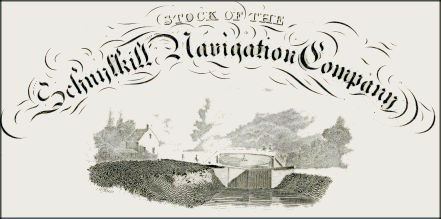
Certificate Vignette The Schuylkill Navigation Company was incorporated in 1815 for the purpose of making the Schuylkill River navigable. The canal or navigation system was constructed between Port Carbon and Philadelphia and covered a distance of 108 miles. Harry L. Rinker in his book, The Schuylkill Navigation: a Photographic History, points out that this "canal" was more properly a "navigation system" because it consisted of 18 dams, 23 canals which covered 57.73 miles, 120 locks, 17 stone aqueducts, one 450 foot long tunnel, 50.50 miles of slackwater pools, 23 canals covering 57.73 miles, and 31 houses for toll and lock keepers when it was completed in May 1825. After 1825 efforts to improve the navigation system were ongoing, so the above number of structures changed over the years. The system was most prosperous between 1835 and 1841 although its record tonnage, nearly two million tons, occurred in 1859. During the second half of the 19th century the rise of the railroad, floods, droughts, and a miners' strike contributed to the downfall of the system. In January 1870 the navigation system, was leased to the Philadelphia and Reading Railroad Company for 999 years although the railroad company was obligated to maintain the system in good condition except for the section north of Port Clinton which was abandoned around 1887. In 1896 the railroad property was sold to Coster and Stetson, but they elected not to assume the lease of the navigation system. From 1896 to 1902 the Philadelphia and Reading Railway Company operated the navigation system, but in April 1902 the Schuylkill Navigation Company resumed operations of the navigation system. In the 20th century commercial use of the navigation system decreased and ended in 1931. In 1949 the Schuylkill Navigation Company was acquired by the Commonwealth of Pennsylvania. In the late 1940s and early 1950s a joint federal and state effort, the Schuylkill River Desilting Project, dredged the river of the coal culm or particles, and constructed desilting basins.
Certificate Vignette


